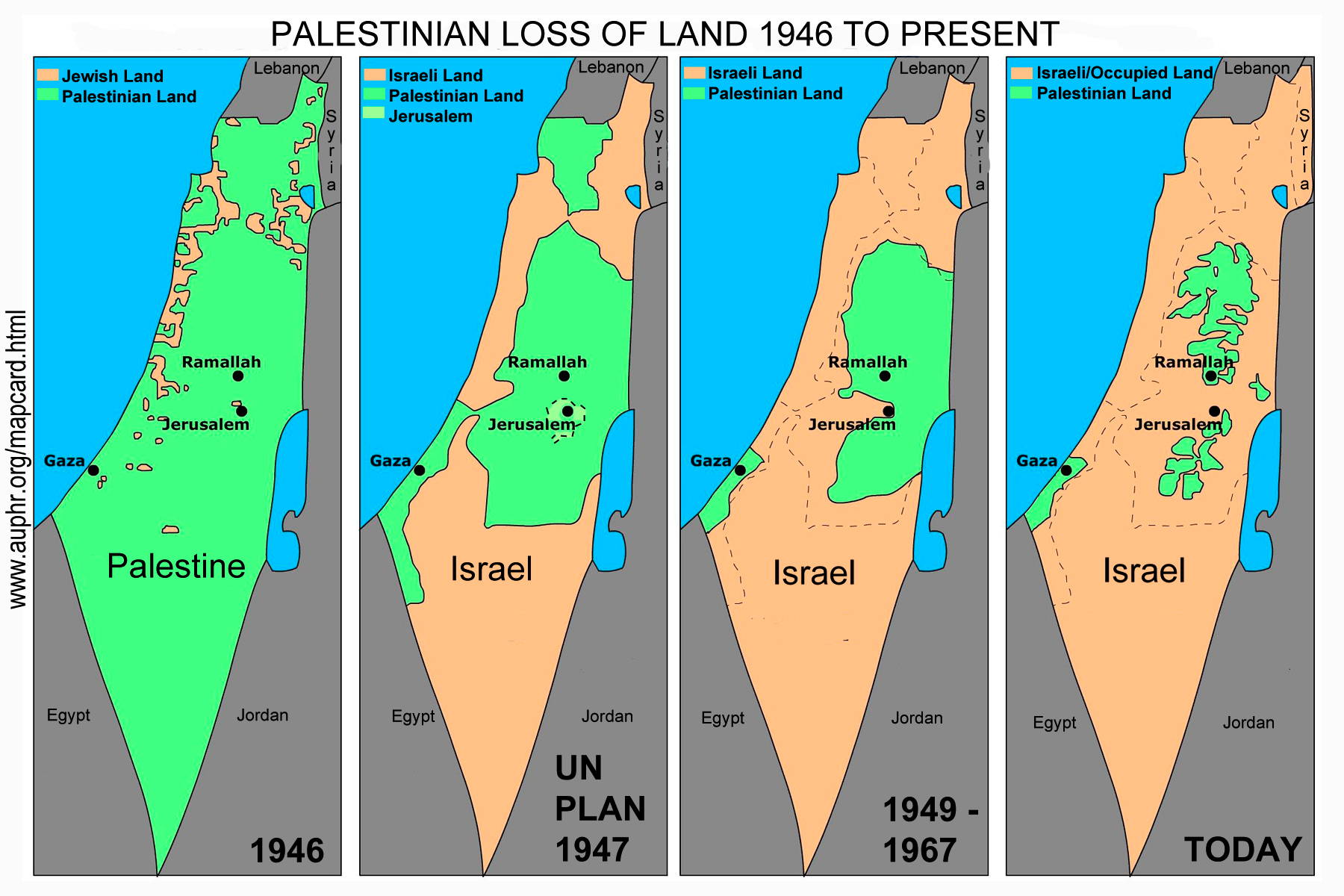
 The "map card" depicting the history of the conflict between Palestinians and Israeli Jews has been a very effective tool in educating people about the conflict and demonstrating that Israel's colonization of Palestinian lands continues aggressively to this day.
These maps attract attention because they graphically tell a story of dispossession.
They point to an important reality: that as Israel has expanded in what was historic Palestine, the majority of the indigenous people of that land - the Palestinians - have either been driven off their land, or, where they remain, have no sovereignty and few rights.
The four panels of the map card depict key periods:
The first map (1946), approximately a year before Israel was created, shows that Jewish communities in historic Palestine owned no more than 6% of historic Palestine and represented 30% of the population.
For a complete report on land ownership pre-1946 and the continued taking of Palestinian lands by Israel, see the 2005 publication on the UN Office for the Coordination of Humanitarian Affairs, Occupied Territories (OCHA-oPt) website: http://www.ochaopt.org/documents/opt_prot_COHRE_Seizure_Of_Land_And_Housing_In_Palestine_may_2005.pdf
The second map (1947) spells out the United Nations partition plan of 1947, which awarded the Jewish community a state on 55% of the land alongside a much reduced Palestine even though Palestinians were the majority of the land’s inhabitants.
 This map never represented a reality on the ground, as the creation of Israel resulted in the Zionists taking 78% of historic Palestine, expelling over 750,000 Palestinians from their homes and depopulating or razing over 400 Palestinian villages in what is now Israel. For more information see Walid Khalidi's book All That Remains: The Palestinian Villages Occupied and Depopulated by Israel in 1948
The third map (1948-1967) displays the armistice lines from the 1948 Arab-Israeli war. In this map Israel controls 78% of the land.
The map has the outlines of the original UN Partition plan to show how much additional land, way beyond any international recognition or mandate, was taken from the Palestinians in 1948.
What Israeli's remember as the birth of their nations, Palestinians remember as the Nakba or "Catastrophe."
For an excellent history of the Nakba, see the book by Israeli historian Ilan Pappe entitled The Ethnic Cleansing of Palestine.
The fourth map is where we are today. In the 1967 war, Israel took control of the West Bank and the Gaza Strip. The Israeli occupation of the West Bank – now in its 46th year in 2013 - is being made permanent as Israel systematically takes more and more Palestinian land to accommodate Israel’s massive settlement project to establish irreversible “facts on the ground”. Over half a million Israeli settlers now live in the occupied West Bank. Under international law, it is illegal for Israel to move Israeli settlers into the occupied Palestinian territories. Israel is on the verge of annexing over 60% of the West Bank.
The UN OCHA-oPt website has excellent resources and maps, including the map of Area C in the West Bank which represents over 60% of the West Bank. Area C is completely controlled by Israel and is actively being developed and settled by Israeli Jews. As you can see, Area C forms the painful basis of the fourth map.
See Juan Cole's article "How a Map of Palestine Drove the American Neocolonial Elite Mad" for how this information is treated by supporters of Israel's occupation and colonization.
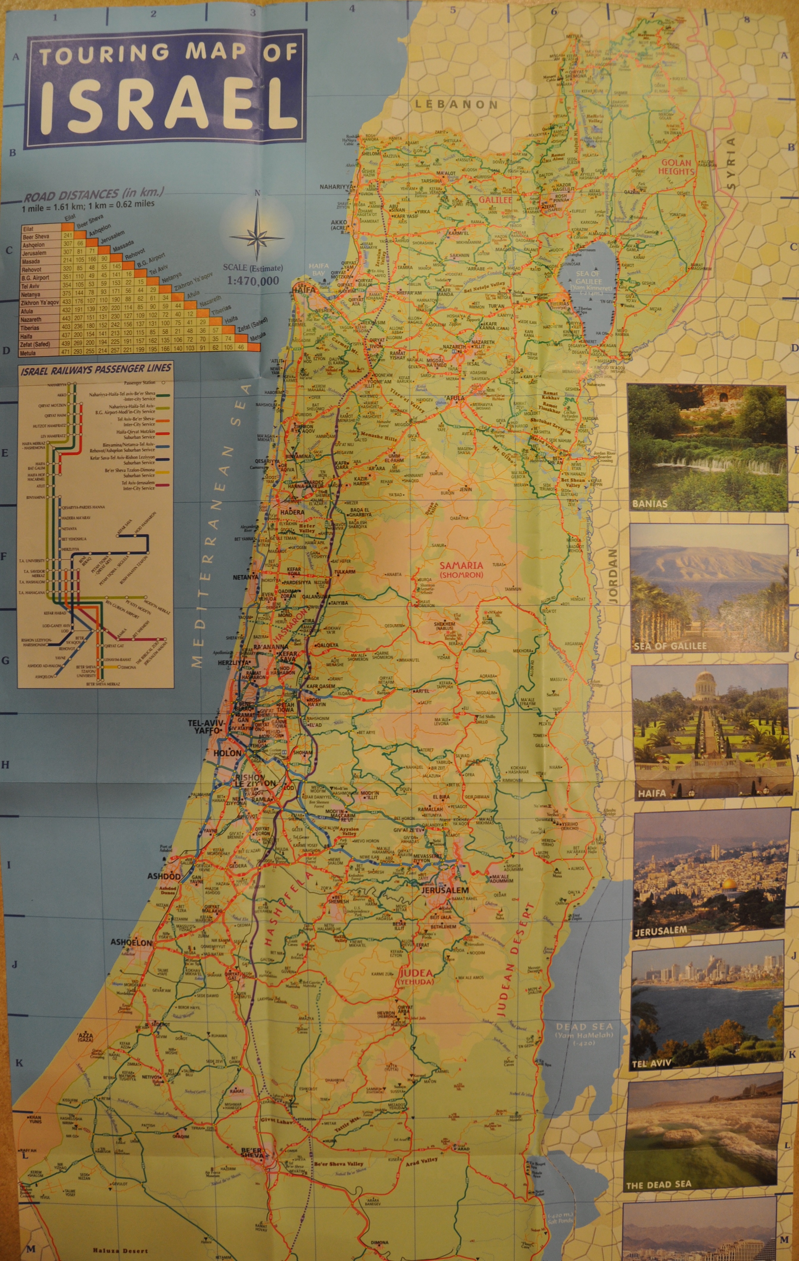
You can also get a map from any Israeli Tourism office that shows the same reality. Israel's own tourist map doesn't show the West Bank borders and shows the Palestinian areas as disconnected islands in a sea of Israel roads, settlements, and control (see also http://goisrael.com/Tourism_Eng/Tourist%20Information/Discover%20Israel/Documents/MapOfIsrael1.pdf)